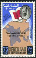
Sharjah Map and Flag - 75 naye paise
This historic stamp was issued in 1963 by the Emirate of Sharjah & Dependencies , printed by the renowned British firm Harrison & Sons Ltd. The central design displays a geographic map silhouette of the Trucial States (الإمارات المتصالحة) situated between the Arab Gulf and the Gulf of Oman, anchoring the emirate's territorial identity prior to the formation of the United Arab Emirates. Overlaid on the map is the red-and-white Trucial States flag, alongside an oval vignette featuring the portrait of Sheikh Saqr bin Sultan Al Qasimi, who ruled Sharjah from 1951 to 1965. This issue served as a foundational regular postal release to assert administrative sovereignty, local geographic boundaries, and regional identity.